Firstcon Forest fire prevention intelligent monitoring and pre-warning system
System Introduction
FIRSTCON Forest fire prevention intelligent monitoring and pre-warning system could warn the occurrence of fire, real-time monitoring the spread of forest fire, and to suggest the right fire suppression decisions. The system mainly uses the front-end equipment to transmit the field information to the command center in a wireless way. The command center uses the system software to integrate the forest scene information and fire protection information around in time, and then compose a complete forest fire prevention monitoring and pre-warning system. Prevent the forest fire as early, precise and complete as possible. The whole system effectively realizes the scientific, digital and informative management of the forest.
System architecture
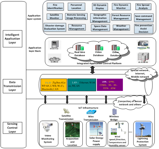
The system adopts three-tier architecture of the IoT (Internet of things), which composes of the sensing layer, transmission layer and application layer. The sensing layer mainly control and gather the parameters of video, audio, anti-theft devices in the forest scene. The transmission layer uses wireless way of Network Bridge, GPRS, and CDMA to transmit the data to command center. The application layer uses these data and integrates the fire extinguishing system to compose a complete forest fire prevention intelligent monitoring and pre-warning system.
Application layer system:1. Smoke and fire recognition, satellite monitoring,
Loss evaluation management, personnel location, Remote sensing image processing, Implemented resource management, 3D dynamic display , geographic information management, space data management , Fire dynamic monitoring, Forest resource management, Weather monitoring, Fire spreading analysis, Fire extinguishing command management, Fire prevention assist decision
Application layer base: Security identification, Middleware, Real-time data base, Video data base,
Other data base , Comprehensive Application platform., Background service
Transmission layer: private network, Internet, Mobile network and the fusion of other network
Sensing layer: Sensing network interworks with communication network
IoT base Infrastructure, satellite communication, wire transmission, wireless network bridge,
Video monitoring system, Acquisition and location system, Intelligent solar energy Power supply system, wind speed, wind direction, humiture Sensor, Lighting protection system.
System function
Pre-warning analysis
The distinguishing of the forest fire pre-warning signal mainly through the data gathered by sensor layer, including dryness, temperature, wind speed such environment factors, while integrate the topographic conditions, vegetation conditions
fire combustion conditions such factors. According to the fire danger level and spread trend, the pre-warning is divided into 4 levels, in turn as blue , yellow , orange , red. According to the predicted fire danger level, the system will automatic submit the information to the designated Forest station and fire station, it is prepared for the fire prevention in advance.
Correspondence between forest fire danger and pre-warning signal
|
Forest fire danger grade |
Dangerous level |
Flammable Level |
Spread level |
Color of prewarning signal |
|
I |
Low |
Difficult |
Difficult |
|
|
II |
Middle |
Flammable |
Can spread |
Blue |
|
III |
A little higher |
Easy |
Easy |
Yellow |
|
IV |
High |
Easier |
Easier |
Orange |
|
V |
Extreme |
Extreme |
Extreme |
Red |
Ø Automatic identification function of smoke and fire
The system has automatic identification function of smoke and fire. When there is an open fire or smoke in monitoring picture, the intelligent video analysis device can recognize it and send warning signal for informing nearby firefighters and fire stations to put out the open fire and prevent it from spreading.
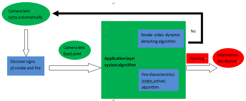
Flow chart of smoke and fire identification
Ø Fire spread analysis function
When the fire happened, the system synthetically simulate predicted fire developing trend according to the information automatically selected by sensing layer, terrain condition, vegetation condition, source of ignition condition, and so on. The main factors that affect fire spreading are:
Weather condition: wind power, wind direction, weather...
Forest condition: tree species, season, area, tree-age...
Geographic condition: Land-form
Fire prevention zone: road, river, fire prevention forest...
Through model to predict effect, using incremental red color to render with superposition to the fire, the system can simulate fire area clearly and accurately that make the ignition process and fire terrain be clear at a glance, so commanders can observe the fire spreading trend and condition some time, and provide fire suppression measures for reference.
Functions of geographic information management and personnel location
Realizing map’s basic operating function is based on the electronic map. Using digital pan-tilt in front-end acquisition system to make address coding for every monitoring point in geographic information system, and mark every coordinate of monitoring point on the electronic map. In this way, the geography information system can realize locating function by establishing specific position-conversion mathematics model once receiving the location date from the digital pan-tilt with specific codes. At the same time, the system has personnel location function which needs locating modes carried by firefighter and provides decision maker fire protection distribution to take extinguishing measure.
1) Fire fighting truck equipped with vehicle-mounted GPS, fire fighter equipped with hand-held GPS;
2) Using GPS tracking system to seek the geography location of fire fighter in real time;
3) Using location service platform to synthesize locating information of application personnel;
4) Large screen of the client displays the marching route of fire fighting trucks and fire fighters in real time.
Personnel location and route map
5)Save the personnel location history trajectory,conducive to inquiry.
6)Realize the playback at any time and of any GPS movement trajectory, which will help to aid decision making.
Extinguishing decision analysis function
When a fire occurs, the system will display the fire location at the first time, and also release fire alarm signal to inform the surrounding firefighters to make function of timely extinguishment. The main characteristics of the function are the following:
l Timely display the accurate location of fires
l Publish a fire alarm signal and show fire danger class
l Display information of surrounding firefighters and fire stations, and timely deploy the nearest firefighters to arrive at the scene to fight the blaze and prevent the spread of the fire.
l Analyze and show the area where the fire is about to spread.
l Display the pretreatment measures of the villages and people around the fire, reference for decision makers.
l Real time monitoring of condition in the fire scene.
Based on the development of the fire, timely display the best measures of fire fighting, including isolation belt, personnel fire control, etc.
l Show route of firefighters and fire engines to achieve personnel location function, reference for decision makers to make better save decisions
Ø Loss evaluation management functions
l The system can be made to evaluate and organize files on disaster damage after the fire, automatically generates the report function. Systems can manually draw fire range and lead drawing through GPS points, automatically calculate the damage area of the fire, record the happening and ending time and date of the fire. Calculate the loss of forest resources for decision-making departments.
l Lightning protection function
l The system shall have security lightning protection safeguards to protect the safe operation of the system.
l Equipment burglar alarm function
Sensing layer device of this system is mainly placed in the field, to protect the user's investment, the front-end devices are equipped with infrared sensor, when there is an invasion of the theft, monitoring center will alarm, and forestry managers can conduct alarm of the theft conditions through the audio device, to minimize the loss to the user.